Showing posts with label GPS. Show all posts

Sunday, September 24, 2023

Competition for Bayocean's Natatorium

Bayocean Natatorium. BOB95, Tillamook County
Pioneer Museum.
On July 5, 1914, the Bayocean Natatorium offered heated, saltwater bathing to the public for the first time (it opened a day earlier, but the boiler didn't work, so it was a chilly dip for those who initiated it). The building took up five oceanfront lots and was more than two stories high. A balcony let folks watch swimmers and kids paddling inflatable canoes around during the day and enjoy movies on a screen pulled down from the rafters at night. Sometimes bands played there. The Bayocean Natatorium quickly became the resort's most popular attraction. 


Seaside's first natatorium was the two-story
part of the Turnaround Building, on the right
(south) side of this photo. The Trendwest Resort
stands there now. Seaside Museum image.
Bayocean Park ads started promising a natatorium after news that construction of Ashland Mineral Springs Natatorium - the first in Oregon -had begun reached Portland in 1909. But 
by the time it was finished, three others operated along the Oregon Coast. Gearhart Park started advertising its little natatorium in the Oregonian on May 22, 1910. The one at Nye Beach opened in 1912. J.S. Oates placed the first ad for his Seaside Natatorium in the Oregon Journal on June 3, 1914. That allowed him to claim its 40' x 80' pool was the largest in the Pacific Northwest until Bayocean's 50' x 160' pool opened a month later. 

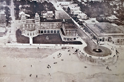
T. Irving Potter tried to regain lost ground by making his natatorium larger than the rest and installing a wave generator he invented. The first of its kind had been used at the outdoor Bilzbad baths in Radebeul, Germany since 1911, but Bayocean's was the first indoor application. Unfortunately, it was difficult to maintain and was offline more often than it worked. The rest of the structure also required constant maintenance, which is why it lost money every year it was open.

When 
BOB 68, Tillamook County Pioneer Museum. 
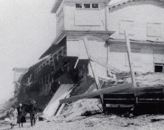
the Rockaway Natatorium was finished in 1926, folks started going there instead of Bayocean because it was much easier to get to and better maintained. As a result, the Tillamook-Bayocean Company (a group of local businessmen) could find no one to lease Bayocean's natatorium, so it stayed closed in 1927 and never reopened to the public. In 1932, erosion that had been moving the waves closer for a decade undercut the west wall during a winter storm, causing it to collapse. The building was later deconstructed and used to build the Sherwood House on Cape Meares. Bayocean Natatorium competitors all lasted longer, but t
he only one still standing is the second one built at Seaside, which now hosts the Seaside Aquarium.  

See the Index for more articles that might be of interest. 

Thursday, March 30, 2017

Crabapple Park

All the low lying Bayocean streets and buildings that survived the November 1952 breach and subsequent erosion were buried by the US Army Corps of Engineers in 1956. Three houses at higher elevation survived initially. The last one fell in 1960. A few streets above the fill line were far enough back to not fall into the sea but were eventually buried by sand carried by the wind. 
Photo from Phyllis Locke Anderson of neighbors
hanging out at the site of the 2015 excavation 

In October 2015, Perry Reeder guided his family in excavating a small section of curb and pavement on the west side of High Terrace (see plat map below), a little north of 12th Avenue, just before it turned northwest and uphill. In my photo to the left, taken soon after the excavation, the curb is the horizontal strip, aligned approximately north/south. The semicircle just below and east of it is the pavement. The spot straddles lots A and 2 in Block 55. It was the spot Perry's family first parked their car in 1944, so they could rent a cabin in Cottage Park from Walter (Shorty) Locke, who lived across the street in lot 4. 

When I asked Perry how he found the spot, he said he used two crabapple trees to get his bearings. I was impressed with his memory and surprised to learn that some fauna had survived the wrath of the sea in this southern section of Bayocean. I'd not noticed them before but photographed them on my next trip. They're nestled in the lee of the highest remaining point south of the hills, lone sentinel to the Bayocean that once was. Using Coast Atlas and adjusting for known discrepancies in tax lot overlays, my best estimate is that the trees are in lot 39 of block 54, perhaps extending into lot 38. Perry said he never met the owners and that no houses were ever built along the south side of 12th Avenue, so it remained park-like. 

Deed records show lot 39 was owned by Gerald and Nellie Reeher during Perry's era, and lot 38 was owned by Martin and Jeanette Nelson. The Reehers eventually lost their lot to the county, but the Nelsons' son Donald is still on record owning theirs. Gerald and Nellie Reeher moved to Tillamook in 1922 and started Reeher Furniture. They moved to Salem in 1935 according to the September 24, 1935, Statesman Journal. They must have become close friends with Francis and Ida Mitchell while in Tillamook because the Tillamook Headlight-Herald reported them giving Francis a ride (from the Oregon State Hospital in Salem) to Ida's funeral in 1953. And when Francis died in 1965, Nellie purchased a joint cemetery lot for them. 


All of this is just west of the Bayocean town site sign put up by the Reeders. Follow the trail to the ocean from it and watch for a trail to the right (north) and a small driftwood fence. GPS coordinates are 45.527324N 123.952463W. To get to the townsite sign, walk north from the parking lot on Dike Road and look for a post engraved "Bayocean Town Site." Follow the trail west. Look for another post on the left and take the trail south from there to the townsite sign. When I visited the excavation in September 2018, I found that sand had already filled the bottom of the hole by more than a foot - the deepest I cared to dig with my hands.

Find other posts in this and other categories on the Index page.  

Friday, August 7, 2015

Locating Bayocean School

One of the buildings Bert and Margie Webber did not locate on their drawings in Bayocean: The Oregon Town that Fell Into the Sea was the Bayocean School. Written reports said it was close to Cape Meares, and Perry Reeder pointed to the area on the original Bayocean Park plat map where the narrow southern section of the spit started to widen out, but I wanted to find the exact location so I can stand there like I had the Bayocean Hotel

When I met Mike Watkins, he remembered that the school had been just a little northwest of the west end of Arthur Beals' dike. The dike had a one-way gate that let Coleman Creek flow out at low tide but kept Tillamook Bay water from coming back in at high tide. This changed the wetland into a meadow that dairy cows could graze. When he came to believe the ocean would eventually take the spit, Beals sold much of his Bayocean/Cape Meares holdings to Mike's grandfather, Robert W. (Pop) Watkins. The land at the east end of the dike passed down to Mike and his siblings, which is why he's so familiar with it. When the breakwater that is now Dike Road sealed the breach in 1957, the ocean beach reformed (east of its previous location) and created Cape Meares Lake. Though the meadow and dike are now submerged, Mike said that remnants of the dike were still visible and could be used to point to where the school had been. 


Corps of Engineers aerial photograph # 39-1546, cropped. 
Then I looked at 1939 aerial photographs from the Army Corps of Engineers. Because it was earthen, the dike is lighter in color and stands out against the grey background. By zooming in, I saw the schoolhouse just northwest (up and left in the photograph) of where the dike ends at the spit, confirming Mike's recollection. I also noticed that the school was in line with 4th Street, which is the road at the bottom of the photograph running south (down) from Bayocean (or Mears) Rd which runs east to west (left to right). Since 4th Street still exists, this gave me two sightlines, which were the same today as in the past, that I could use to find where the school had been on today's landscape. 

That would have been good enough, but while looking at the Tillamook County Tax Map for other reasons I noticed an active tax lot in the area. The Summary Report for lot #1200 shows it's owned by Tillamook County School District #9. Like many other landowners, they'd kept ownership over the years. ORMAP and other GIS mapping systems project county tax lot layers onto modern aerial landscape views and provide GPS coordinates where a cursor is placed. Coordinates at the center of the school lot are 45.505148 N, 123.958730 W. The school may not have been at the center of the lot, but since the tax lot is only 100' x100' (.23 acres) it couldn't have been far from it. Now I had two ways to locate the school. 

The next step was a field trip. Mike was gracious enough to lead me down a trail (viewing deer and an eagle along the way) to what had been the east end of Beals' dike. From there we were able to sight the west end using dike remnants. We then hiked out on the spit. Sighting south to 4th street, and east along the dike, we arrived at a spot on the beach where the coordinates matched. We were there! The spot is just 1/10 mile north of the parking space at the end of Bayocean Road, so easy to reach, and a stump just east of the spot makes it hard to miss. If the ocean reclaims or moves the stump, the coordinates will still work. Based on the aerial photograph and county tax map, the road out to Bayocean from Cape Meares would have been about 500' west of the spot. The average high tide in 1939 would have been about 1000' out. 

Left to right: James Bennett, Rosemarie Bennett, Barbara Parker,
Russell Parker; photo from Tillamook County Pioneer Museum
When I asked, Mike recalled the school grounds being about 10-15' above sea/bay level. After leaving Mike, I saw Harold Bennett in his yard. He had attended Bayocean School, so I stopped to let him know about the stump, and asked him what he thought the school elevation had been. His answer was the same as Mike's. I later found a 1939 USACE topo map confirming Mike's and Harold's recollection. When you stand there, listen for the yells of children at play in the wind above you. 

Thursday, July 30, 2015

Dolan House

With the help of Facebook groups and friends, one of the two houses next to the Hicks house is now known to have been last owned by A.T. and Hazel Dolan. All three houses were built by wealthy Portland lumberman Johan Poulsen and continually owned by family members until 1944. They were known to the be the most extravagant homes on Bayocean, which seems fitting given their placement catty-corner to the Bayocean Hotel Annex, on the highest point on the spit (What Happened At Bayocean: Is Salishan Next? Expanded Edition12-13). Though photographs exist for many Bayocean houses, few are identified, and even fewer are located. That's why it's such a pleasure when one can be nailed down. 


Photo of the front (eastern side) of the Dolan house  taken by Dorothy Dolan Williams (daughter)
in 1945.  From left to right, standing to sitting: Hazel Wolfe Dolan, a visitor whose name has been forgotten, Joann Dolan Steffey (daughter), and A.T. Dolan
Tom Williams is a Tillamook, Oregon native who enthusiastically introduced me to several Facebook historical interest groups a few months ago. The Dolans were his grandparents. They lived in Tillamook and used this as a beach house. Tom was born too late to visit them there, but ever since his grandmother told him she'd watched a blimp drop depth charges on a submarine right out in front of the house he'd wanted to find its location.

Peter Bellant has an excellent Bayocean album in Oregon History and Memory's collection. I recently noticed that one of the photos was captioned "The Dolan house at Bayocean." When I alerted Tom he posted the photo at Old Tillamook Times, where most Bayocean alumni congregate, including his cousin, Barbara (Steffy) Sisson. She then acted as an intermediary with her mother, Joann (Dolan) Steffey, Tom's aunt, his mother Dorothy's sister, and the Dolans' daughter. 

Joann confirmed it was her parent's house and provided the information in the caption (she also confirmed watching the blimp drop grenades on a submarine, watching it happen alongside her mother). Next, by looking over the drawing at Bayocean Then And Now, Joann recalled the house being just west (and north) of the Hicks house. Luckily there are many photos of the three Poulsen houses. Joann confirmed that it's the house on the left in the photo below.

Dolan house on the left. The view is of its southwest corner, from the northeast corner
of the Bayocean Hotel Annex across the street.  Tillamook County Pioneer Museum #93


Unlike the Hicks house, the Dolan house was not moved to the mainland. Nor was it destroyed by the sea. It burned to the ground late in January 1950. Joann said that her father let the family of his friend A.G. Beals' son Roland stay at the house when they moved there just after the start of the school year. Roland's son Bruce was a new classmate who she had dated. The fire started when Roland used gasoline to help get a fire going in the woodstove. He was badly burned and the house burned to the ground. Most all of the Dolan's Bayocean memorabilia were destroyed in the process. This was a hard blow to Joann's parents, who never spoke of it again.

Sad as the story is, at least Tom (or anyone else) can now stand under the Bayocean Hotel Annex chimney (45.52982, - 123.954258) at low tide, hike about 380' bearing N 60 E, look 110' into the sky, and imagine what it might have been like for his grandmother to see and hear the depth charges dropped by the blimp over 70 years ago. 

Thursday, May 14, 2015

Walking Past The Pier

Letter from Potter to Beebe  at
Tillamook County Pioneer Museum
Looking at photographs of the Bayocean pier, where boats docked in Tillamook Bay, you can see that it was quite long. I wanted to know exactly how long, to see if I crossed the spot where it would have been hiking on Dike Road now. Luckily, the Tillamook County Pioneer Museum provided the answer, by way of a letter in their collection that T.B. Potter wrote to Charles Bebee in 1911 saying the pier was 1400 feet long, just over a 1/4 mile. 

The pier was an extension of 12th Avenue, which stopped at Bay Street. The Bayside Inn was on the southeast corner of that intersection. If you were arriving by boat, you could just walk off the pier and check-in. Tillamook County Tax Map 1N1031D shows Dike Road 500' east of that intersection, so the pier would have extended 900' past the road into Tillamook Bay, nearly out to the oyster beds. 

Photo from Tillamook County Pioneer Museum
Where the pier would have crossed Dike Road is about 1/2 mile north of the parking lot gate. It's close to a sandy spot on the west side of Dike Road.  If you have a GPS reader it will be at latitude 45.527 (since the dock was pretty wide we don't need to go beyond three decimal points). When you get there, stop for a moment and imagine hiking out to watch the "dinky" railroad engine unload construction materials from a barge.

Friday, March 13, 2015

Stand Under Bayocean Hotel Annex's Chimney

Would you like to stand on the beach precisely 100' below the spot where the chimney of the Hotel Bayocean Annex stood 100 years ago? Well, you can, thanks to NOAA's National Geodetic Service (NGS) and its database of survey control station datasheets kept on file even after the actual station (monuments similar to those by surveyors) no longer exist. 

Excerpts from the datasheet for KINCHELOE (RD2010):
       
DESCRIBED BY COAST AND GEODETIC SURVEY 1926 (JMS). STATION IS LOCATED ON TOP OF CENTER BAFFLE WALL OF LARGE BRICK CHIMNEY, SITUATED ON TOP OF LARGE HALF CONCRETE, HALF FRAME, WHITE HOTEL AT BAY OCEAN, OREGON...

RECOVERY NOTE BY COAST AND GEODETIC SURVEY 1932(LAM) ...THE STATION IS IN THE TOP OF THE CHIMNEY OF THE LARGE, WHITE BAY OCEAN HOTEL, UNOCCUPIED IN 1932...

RECOVERY NOTE BY COAST AND GEODETIC SURVEY 1954 (FN). THE HOTEL ON WHICH THE STATION WAS LOCATED HAS BEEN  COMPLETELY DESTROYED AND WASHED OUT TO SEA BY THE OCEAN CURRENTS...

Photos show the chimney to be about 33' tall. So, the station would have been at an elevation of about 133', the highest man-made point on the spit.

Coordinates translated into decimal degrees are 45.52982, -123.954258. The chimney appears well out to sea on the NGS map, but you can reach it at medium to low tide. Everything west of the vegetation line (including the beach) is evidently colored blue.

Web sites like ORMAP and Coastal Atlas project the Bayocean townsite onto current areal views, so are more realistic; but they don't label the streets. Just keep in mind that the Annex was in the large block just southwest of 14th Street and Laurel Avenue (see the map at Bayocean Then And Now).  

The other historical datasheet of significance is for CORN RD2011, coordinates  45.52683, -123.951464. Excerpts from it:
DESCRIBED BY COAST AND GEODETIC SURVEY 1954 (FN) LOCATED ABOUT 7 MILES NORTHWEST OF TILLAMOOK NEAR THE SOUTHWEST CORNER OF WHAT IS LEFT OF BAY OCEAN ON THE SOUTHEAST SIDE OF A PROMINENT PAVED STREET INTERSECTION ABOUT 260 FEET WEST OF THE WEST SHORE OF TILLAMOOK BAY AND ABOUT 8 FEET ABOVE MEAN HIGH WATER.  STATION IS THE CORNER OF A DILAPIDATED LARGE TWO STORY FLAT-ROOFED BUILDING UNPAINTED ON SOUTH AND EAST SIDES AND PAINTED WHITE ON WEST AND NORTH SIDES.  POINT     INTERSECTED IS APPROXIMATELY 35 FEET ABOVE MEAN HIGH WATER AND IS THE     NORTHEAST CORNER OF THE BUILDING AT THE TOP OF THE SECOND STORY.

This was the Bayside Inn (see Bayocean Then and Now ). If you visit the coordinates today you'll find that the Reeder family and Tillamook County surveyors have installed signs nearby to locate what had once been the center of Bayocean commerce. After the 1952 storms made an island of Bayocean, the Mitchells hung on for a while but had left by the time "FN" visited the site in 1954. When the dike was built to reconnect Bayocean with Cape Meares in 1956 the store and other ruins were bulldozed and burned. The area was then leveled with sand dredged from Tillamook Bay.

Saturday, February 28, 2015

Rewitness Card #56

1/4 corner common to Sections 30/29 of 1N10W on Bayocean
On January 1, 1987, a Tillamook County survey crew made up of Al Duncan, Al Dvorak, and Dan McNutt rewitnessed (confirmed and reestablished as needed)  the monument for the quarter corner common to Sections 29 and 30 of Township 1 North, Range 10 West of the Willamette Meridian. On February 24, 2015, I found and photographed the brass cap they set in concrete to replace a wood post Samuel Snowden and his crew had placed there on April 1, 1857, as part of the first General Land Office (GLO) survey of Tillamook County. It's the only one of their monuments remaining on. I know because I've thrashed around in the pucker brush looking for any sign of the others. 

This monument survived, while the others did not, because it served as the Initial Point for Bayocean Park, from which all streets and lots were measured. Zoom in on the plat map and you'll see it at the far west end of 22nd Avenue. The Government Reservation border is the line dividing Sections 29 and 30. Since this one is further from where the town center had been than other monuments, it must have been the only one Harkness Chapin could find when he surveyed the spit in the spring of 1907.


Samuel Snowden GLO Field Notes April 1, 1857
In 2008, Terry Jones, of Bayside Surveying, surveyed the property discussed in Bayocean Eco-Park Rejected. His report refers to Rewitness Card # 56, which details the 1987 event discussed above. Jones also provided Oregon State Plane Coordinates for the monument, which Dan McNutt (now Tillamook County Surveyor) kindly converted to latitude/longitude (N  45.5442559 / W 123.9471265) so that I could find it.

Rewitness Card #56 discusses the conditions relative to what deputy surveyor Snowden wrote in his field notes on page 43 of OR-R0053. Snowden and the five other members of his crew hiked the entire length of Bayocean in one day, setting posts on dunes and in the hills along the way. He noted salal underbrush and forests in his notes, but it could not have been as dense as today for them to cross it from south to north in one day. Snowden also mentioned a lone Indian hut on the shore of Crab Harbor. 

Wednesday, January 21, 2015

Bayocean's Highest Point

In Bayocean: The Oregon Town that Fell Into the Sea, Bert and Margie Webber wrote that the Bayocean Hotel was built at 140' above sea level, the highest point on the spit. However, an ad placed in the Oregonian on October 4, 1909, by thPotter-Chapin Realty Company, bragged of it standing at just 100'. A 1939 map drawn by the US Army Corps of (USACE) Engineers showed a 100' topographic line surrounding the hotel ruins. The Webbers must have seen brochures and other ads bragging that the hotel would be built on Bayocean's highest point and assumed that the USACE was referring to that spot when it said Bayocean's highest point was 140' in a 1940 study. Both were incorrect. 

In 1957, the USACE produced a more comprehensive map with the highest point shown at 154'. Studies on Bayocean, including some written by USACE, continued to use the 140' high point long after that report came out, likely because it was not widely distributed. I found this report at the National Archives in Seattle a few years after I hiked to the highest point myself, which was more fun.

Soon after Bayocean's history caught my interest, I began wondering what the elevation of the highest point was today, assuming it was lower than the hotel elevation. So I roamed Bayocean on Google Earth with my cursor noting the elevations shown in the margin. I found one at 126 feet and headed out there on December 16, 1914, with my friend Eleanor to find it. Later, looking at Google Earth again, I found several spots higher than 140' and tagged the highest one at 153' (the aerial view of it below is looking northwest towards Tillamook Bay). This made me realize that it's likely no one has ever been to Bayocean's highest point due to its remote location being a spot where nothing was ever built. With coordinates in hand (45.538290 -123.945063), Eleanor and I set again January 19, 2015. 


On a map, the shortest route to the high spot is a direct line west from Dike Road. We discovered that this would require hip boots we didn't have in order to get across a marsh, followed by a tough push up a steep incline through the nearly impenetrable brush. So we returned to the road and hiked south, then followed an established trail across the "sand gap" shown on maps, and headed uphill from a spot directly south of the high spot. We needed all of our tools (map, compass, GPS app) because the trees and other foliage was so thick in places we couldn't see far in any direction. At one point I entered info on my GPS app incorrectly, which forced us to backtrack. We tried using deer trails but they just led to dead ends where they bed down at night. Often we had to crawl under the brush to make headway. Luckily, when we got close the exact spot it was made obvious by a tall tree centered in a little knoll that stood above the surrounding turf. My GPS app registered 152'. We decided to try a shorter route back, hoping to avoid such extreme bushwhacking, by heading southeast on a ridgeline back to Dike Road. 

Eleanor at Bayocean's high spot
We figured going down a steep slope with no marsh at the bottom would be a snap. It wasn't. The brush was thicker there than anywhere else. Allowing our bodies to fall forward and down into the brush, picking ourselves back up and doing it again, was the most effective approach. I was impressed by Eleanor's sense of humor, fortitude, and willingness to put up with such a lousy trip leader.

Later, when I told Jonathan Allan, a coastal geomorphologist with the Oregon Department of Geology and Mineral Industries what I'd learned, he said this highest point was shown on their LIDAR map at about 153'. Sea level rise over the last 60 years would have been enough to lower the elevation from above to below 153.5'. Rounding up and down does the rest in explaining how 154' in 1959 shrank to 153' today.