Sunday, September 24, 2023

Competition for Bayocean's Natatorium

Bayocean Natatorium. BOB95, Tillamook County
Pioneer Museum.
On July 5, 1914, the Bayocean Natatorium offered heated, saltwater bathing to the public for the first time (it opened a day earlier, but the boiler didn't work, so it was a chilly dip for those who initiated it). The building took up five oceanfront lots and was more than two stories high. A balcony let folks watch swimmers and kids paddling inflatable canoes around during the day and enjoy movies on a screen pulled down from the rafters at night. Sometimes bands played there. The Bayocean Natatorium quickly became the resort's most popular attraction. 


Seaside's first natatorium was the two-story
part of the Turnaround Building, on the right
(south) side of this photo. The Trendwest Resort
stands there now. Seaside Museum image.
Bayocean Park ads started promising a natatorium after news that construction of Ashland Mineral Springs Natatorium - the first in Oregon -had begun reached Portland in 1909. But 
by the time it was finished, three others operated along the Oregon Coast. Gearhart Park started advertising its little natatorium in the Oregonian on May 22, 1910. The one at Nye Beach opened in 1912. J.S. Oates placed the first ad for his Seaside Natatorium in the Oregon Journal on June 3, 1914. That allowed him to claim its 40' x 80' pool was the largest in the Pacific Northwest until Bayocean's 50' x 160' pool opened a month later. 

T. Irving Potter tried to regain lost ground by making his natatorium larger than the rest and installing a wave generator he invented. The first of its kind had been used at the outdoor Bilzbad baths in Radebeul, Germany since 1911, but Bayocean's was the first indoor application. Unfortunately, it was difficult to maintain and was offline more often than it worked. The rest of the structure also required constant maintenance, which is why it lost money every year it was open.

When 
BOB 68, Tillamook County Pioneer Museum. 
the Rockaway Natatorium was finished in 1926, folks started going there instead of Bayocean because it was much easier to get to and better maintained. As a result, the Tillamook-Bayocean Company (a group of local businessmen) could find no one to lease Bayocean's natatorium, so it stayed closed in 1927 and never reopened to the public. In 1932, erosion that had been moving the waves closer for a decade undercut the west wall during a winter storm, causing it to collapse. The building was later deconstructed and used to build the Sherwood House on Cape Meares. Bayocean Natatorium competitors all lasted longer, but t
he only one still standing is the second one built at Seaside, which now hosts the Seaside Aquarium.  

See the Index for more articles that might be of interest. 

Sunday, September 10, 2023

The Hillsboro Connection

Postcard courtesy of Mark Moore, "Oregon Electric Railway"
by Richard Thompson,  Oregon Encyclopedia. 
Bayocean was closely connected to Hillsboro from the start. Sales and construction of the resort would not have begun if, in September 1906, Elmer Lytle had not promised Tillamook County completion of his Pacific Railway and Navigation Company (PNRC) by the end of 1908 in exchange for their guaranteeing rights of way from the county line and land for a Tillamook Station. Lytle did not keep his promise - which was the primary reason the resort failed financially  - but passengers from Portland could travel to Tillamook (after reaching Hillsboro on the Oregon Electric Railway) on the PNRC after November 10, 1911. 

Lytle lost his PNRC to the Southern Pacific Railroad soon after it was finished. The Port of Tillamook took over increasingly more of the line after 1983, until a flood damaged so much of it in 2007 that it was shut down permanently.("Port of Tillamook Bay Railroad"). It's now destined to become the Salmonberry Trail, for the benefit of hikers and bicyclists. Just for the fun of it, I hiked all accessible existing sections in 2022. I also visited the original Hillsboro station after finding out it still stood in the same location. The photo to the right is of its northeast corner, taken from SE Cedar Street looking towards S 1st Avenue, the same perspective as the postcard above.


Card provided by granddaughter Sue Bagley Barr.
Because of this key transportation link, many of the people involved with the Bayocean during the half century it existed were from Hillsboro. The most prominent of them was Judge George Bagley. In addition to serving as Tillamook's Circuit Court Judge, he owned cabins on the spit. So did others from Hillsboro, like the Currins


In addition those cited here, see Bayocean: Atlantis of Oregon for additional sources and information. If you are unfamiliar with the Bayocean story, please read The Bayocean Story in Brief.  Look at the Index to find more articles that might be of interest. 

Friday, June 9, 2023

The Hough House Suffers a Slow Demise

As noted previously, The Last House on Bayocean fell to the sea in 1960. Another home within the Bayocean Park subdivision succumbed later, but it was on Cape Meares, so not tallied among the 59 lost. It was located on the southeast corner of 2nd Street and 1st Avenue (now Bayocean Road) as shown on the original Bayocean Park plat map.

Culp 115 image (undated), Lorraine Eckhardt.
Erosion hit the mainland as hard as the spit, but owners simply moved their houses back from the advancing sea, in some cases, multiple times. Unfortunately, this house was too big to move. Instead, its empty, deteriorating shell provided tourists something to explore and photograph. On November 20, 1958, the Tillamook Headlight-Herald said it sat “deep in debris and rocks as the beach moves farther inland.” Since no specific day it was taken by the sea was ever noted, it must have slowly given way over many years. 

After Bayocean: Atlantis of Oregon was published, I heard from David Hough, son of Lawrence (Evert) and Edith Hough, the last owners of this house. The 1943 photo he sent is the first I'd seen of it shown in a livable condition. It has the same perspective as the Culp image above, providing a before and after comparison. David also described it: "The Bay Ocean house was a bit primitive. We had running water, probably from the Cape Meares system, and electrical power, but limited plumbing. Heat was from a single woodstove. The house sat just above the water level of the nearby swamp, and there was an outhouse perched at the end of a sploshing board walk." 

I hope the publication of Bayocean: Atlantis of Oregon prompts others to share their personal Bayocean stories and photographs. 

Find more article in the Index tab

Friday, May 26, 2023

Bayocean Losses Tallied

At one time or another, the resort town of Bayocean included everything listed below, as chronicled in Bayocean: Atlantis of Oregon. Absolutely nothing remains. 

59 Residences (not all stood at the same time; the number peaked at 36 in 1939):
30 slid to the sea, undercut by erosion 
  8 were deconstructed 
  6 were moved off the spit before it became an island in 1952
  4 burned down for lack of a fire department
  9 were burned, and buried to enable construction of the breakwater  that reconnected the island to Cape Meares in 1956
  2 had unknown fates 
Rock crusher: used to manufacture 3.5 miles of concrete streets  and sidewalks along High Terrace and Twelfth Avenues                Two schoolhouses
Machine shop 
Warehouses: at least two; many untallied outbuildings 
Kaaran Ann Kottages: a duplex
Cottage Park42 rental cottages (the number and style varied) 
Annex: 38 guest rooms and a restaurant
Amusement Pavilion: a three-sided structure including a bowling alley, billiard room, ice cream parlor, game room, and curio shop
Tennis courts
Bayside Inn: 24 guest rooms and a restaurant 
Three dance halls: at different times, the last put up by Reed College students when they ran the resort in 1921
The Mitchella mercantile with at least three apartments upstairs
Pierone quarter mile long, with a harbor for ocean-going ships
Water lines: run from Coleman Creek on Cape Meares
Sewer lines: run along High Terrace and Twelfth Avenues 
6-7 million cubic yards of sand: which would have filled a cube 545’ to  573’ on each side, roughly two Portland city blocks and the street between

To find other articles of interest, see the Index or scroll through them on the Home page. 

Wednesday, April 19, 2023

Post Offices and Postmasters

In Bayocean: Atlantis of Oregon, I discuss changes in the name, location, and postmaster of all of the post offices on Tillamook Spit and Cape Meares, from the first in 1891 to the last in 1954. Below, I summarize that progression and list every postmaster who served during the sixty-three year span. 

The first post office on Tillamook Spit was dubbed Barnegat by Absalom Hallock, who set up shop in his cabin just north of Jackson Gap. When he died a year later, Webley and Mary Hauxhurst's daughter Lizzie (wife of Bert) and then daughter-in-law Carrie (wife of Joseph) ran the Barnegat Post Office out of their homes on Biggs (now Pitcher) Point. Cape Meares Lighthouse keepers then served as postmasters until the construction of Bayocean Park began. For more on this era, see Barnegat Before Bayocean.  

Mary Jones (wife of construction superintendent George Jones) stamped Barnegat, and Bayocean after the name was changed, on envelopes inside a tent. 
The next superintendent, Jim O'Donnell, took on the role himself, but continued working out of a tent until workers finished the administration building - later known as the Bayside Inn - and amusement pavillion, where it was also housed from time to time. (The photo to the left and those below are from the Tillamook County Pioneer Museum.) 
For most of its forty-one years the Bayocean Post Office was located in
The Mitchell, and Ida Mitchell served as postmaster, although her husband Francis performed the duties most of the time.

When Gladys Hoover took over as postmaster, she moved the post office into one of the Cottage Park bungalows she and her husband Russell owned.

At the end of October 1951, the Bayocean Post Office was moved to a new building at
 the southwest corner of 4th Street and Bayocean Road on the mainland (Cape Meares) section of the Bayocean Park subdivision. By then, erosion of the sand gaps on the spit let waves wash out the road so often that delivery into town was unpredictable. The name was changed to reflect the new location a year and a half later. Ten months after that, the Cape Meares Post Office was shut down and mail delivered by automobile thereafter. 

The list of postmaster assignments below is from the microfilmed Record of Appointments of Postmasters, 1832-1971, at the National Archives and Records Administration. I viewed them at the Seattle branch originally, but a digitized version at  Ancestry.com now makes them more accessible. I corrected misspellings caused by transcribers working with poor handwriting and/or deteriorating media. 

Barnegat Postmasters
  • Absalom B Hallock          28 Apr 1891
  • Lizzie Biggs                     26 Mar 1898
  • Carrie A Hauxhurst          20 Jun 1898
  • Hermann Grossheim        18 Oct 1900  
  • George Hunt                      3 Feb 1902
  • George H Higgins            17 Aug 1901
  • Mary Jones                      14 Sep 1907

Bayocean Postmasters

  • Mary Jones                       24 Feb 1909
  • M J O'Donnell                      3 Jul 1909
  • Walter L Johnson             14 Nov 1913
  • David C Baker                    7 Oct 1915
  • Geo J Burckard                  9 Dec 1915
  • Francis D Mitchell            26 Sep 1918
  • Arthur L Springer                5 Feb 1923
  • Mrs Cosia N Oakes            3 Sep 1924
  • Miss Ida J Mitchell             8 Sep 1926
  • Stockwell H Cornelius      12 Oct 1926
  • Mrs Betty H Watkins         18 Apr 1928
  • Mrs Ida J Mitchell             23 Apr 1930
  • Mrs Gladys L Hoover        1 Aug 1946
  • Mrs Evelyn H Reeder      31 Jan 1950
Cape Meares Postmaster
  • Mrs Evelyn H Reeder        31 Mar 1953 - 31 Jan 1954

To find other articles of interest, see the Index tab.

Friday, April 14, 2023

Bayocean The Playground of the Pacific Northwest

The same year (1913) that Southern Pacific Railroad produced its first "Sea Shore Tillamook County" brochure, it collaborated with the T. B. Potter Realty Company to produce "Bayocean The Playground of the Pacific Northwest." Its seven pages feature drawings and photos of Bayocean Park and a Pacific Railroad & Navigation Co. map showing how to get there. The entire brochure can  be downloaded from the State Library of Oregon online. I include page 6 here because it shows seven of the fifty-nine houses eventually destroyed that I discussed recently in Bayocean Homes and Their Fate and cover extensively in Bayocean: Atlantis of Oregon. 

Saturday, March 18, 2023

Bayocean: Atlantis of Oregon Published

I'm pleased to announce the publication of Bayocean: Atlantis of Oregon (BAO). Its 290 pages of text and 57 photos, maps, and charts chronicle the story of the only resort town in the world completely destroyed by the sea due to human error. 
I encourage folks to purchase it from one of the local vendors listed on the Book Availability page. 

Folks unfamiliar with the Bayocean story may want to start by reading my Bayocean Story in Brief. As for BAO, Neal Lemery wrote an extensive book review in the Tillamook County Pioneer, and Amazon includes its introduction, table of contents, and index in its Look Inside preview. You're likely to find familiar names in BAO's index because the Bayocean story reaches far beyond Tillamook County. People from Portland, Spokane, and other cities across the Pacific Northwest, San Francisco, Half Moon Bay, and other cities in the Bay Area, and Kansas City, Missouri were involved throughout its half century of existence. 

I apologize to Bayocean enthusiasts who've waited three and a half years since I first announced having started drafting a book, b
ut I kept discovering new details and interconnections that needed to be worked out as I parsed out 30 GB of data stored on my computer. And I was forced to seek new sources to help clarify discrepancies and debunk myths. Fitting everything into a reasonably sized, chronological narrative was also time-consuming. 

I regret the passing of several Bayocean alumni before they could read BAO and see my acknowledgement of their contributions. As I say in its introduction, Bayocean's history would be more interesting than most small towns even if it still existed; that it doesn't is why telling it matters, now more than ever, while some of those who experienced its destruction are still alive. 

Monday, November 21, 2022

Bayocean Homes and Their Fate

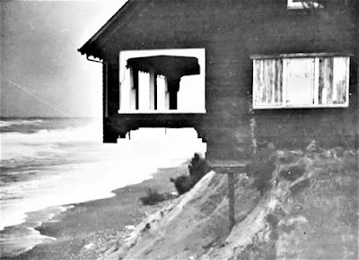
 The house last owned by Harry Roberts, photographed by the 
Corps of Engineers in February 1940, not long before it fell. 
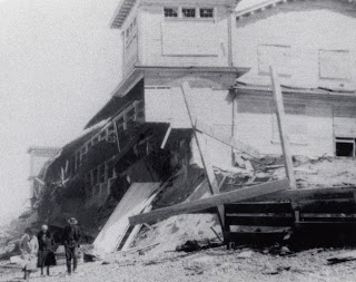
After first hearing about Bayocean eight years ago, I set out to locate the  schoolhouse and six cabins  (counting the Pagodas as two) moved to the mainland before the south end of the spit was blown out by a storm surge in November 1952, a disaster from which the resort town never recovered. I had just located the last of them when Grant McComie called in June 2015 to ask for assistance regarding a program on Bayocean. I then thought it would be interesting to know where the buildings were located on the spit. That led to an obsession with finding every residence ever built on Bayocean, and to learning as much as I could about the homeowners who lost them.  It took me another seven and a half years to achieve that goal. 

If Bayocean Park had been platted in the 1970s, it would have been much easier to locate buildings because property owners would have been required to purchased permits and get an inspector's approval before occupying their homes, resulting in a detailed chronological record readily accessible at the Tillamook County Courthouse. But while the resort town of Bayocean existed, none of that was the case. Homebuilding was a kind of free-for-all. So, I was forced to look for names in newspaper articles, then search deed indexes at the county clerk's office, track ownership back and forth, and go back to look for the other names in newspapers.

Most large metropolitan newspapers like the Oregonian were digitized, so I was able to search them online, but that was true of very  few Tillamook County newspapers. So, I read every original edition or microfilmed copy looking for any mention of Bayocean. Information I was excited to find one day often conflicted with information found elsewhere later. Personal memoirs, government reports, and other archival records helped me parse it all out and fill in gaps. I ran into many dead ends along the way, but most of the remaining pieces of my self-induced Bayocean puzzle fell into place when Denise Vandercouvering, Tillamook County Assessor worked out a way for me to look through historical assessment rolls stored in the courthouse basement after I learned they were organized chronologically by subdivision - just what I needed. 

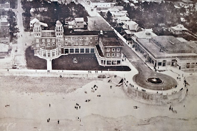
In Bayocean: Atlantis of Oregon, hopefully published in the next couple of months, I will tell the story of homeowners I was able to find, so readers can get a sense of what they experienced. And I mention at least the first and last owners of each of the fifty-nine houses built and lost on the spit. Some were magnificent, some were shacks or converted garages, but they were all considered home by someone. 

My tally does not include houses on the mainland - one of which was destroyed, others moved, some more than once - because my book is about the spit, which I consider everything north of South Gap (Shell Street and 2nd Avenue) because it was the southern limit of the November 1952 blowout. I counted the Pagodas as two houses because one was built later than the other on the spit, lived in by different individuals, and referred to as such by neighbors. Others might choose criteria that result in a different tally. 

To help myself and readers keep track of the fifty-nine residences, I built a spreadsheet listing each one, their demise, lot numbers, and the last names of each owner. Unfortunately, it was too large to include as an appendix in my book, but you can view and/or download it here. Locating each home will require you to view and/or download the Bayocean Park plat map, which I could not fit on two pages pages of my book and provide sufficient detail. 

For more stories about Bayocean and the challenges of researching it, check out the Index page. To reach a comprehensive narrative, read Bayocean: Atlantis of Oregon

Saturday, February 26, 2022

The Tillamook Indians and Bayocean

Tillamook (Kilamox) Indians lived on the sandspit that would become Bayocean Park for centuries before white men arrived. European fur-trading ships began plying the shores of Oregon at the end of the 17th century, but the first recorded interaction was when Captain Robert Gray sailed the Lady Washington into Tillamook Bay and anchored in Crab Harbor on 
Lucia Wiley’s 1943 WPA painting of Captain Gray's 
interaction with Tillamooks, from Wikimedia Commons. 
August 14, 1788. Third mate Robert Haswell’s log (reprinted in the June 1928 edition of the Oregon Historical Quarterlydetailed the event. After a couple days of peaceful trading at a seasonal camp on Kincheloe Point, Gray’s black servant Markus Lopeus got into a squabble with a warrior over his cutlass that ended with Lopeus’ death. Haswell, who was wounded in the ensuing skirmish between warriors and sailors, dubbed the unnamed bay “Murderers Harbour” as they sailed away. Given the aid, Chief Kilchis gave white settlers beginning in the 1850s, it is ironic that the first known battle between any Oregon Indian tribe and white men occurred on Tillamook Spit. 

A permanent village at the south of the end of the spit, in the meadow where the Bayocean School that is now the Cape Meares Community Center was later built, probably was the home base of the warriors who battled Captain Gray's men. In his 1948 diary, archived at the Tillamook County Pioneer Museum, Bayocean resident Jack Medcalf described longhouse ruins and a large midden there. The location is shown on page 175 of Tillamook Indians of the Oregon Coast, but the landscape in the photo has changed dramatically since then. On page 158, beeswax is reported to have been found there, which would have come from Nehalem Bay Tillamooks who salvaged it from the Spanish Galleon Santo Cristo de Burgos after it wrecked during the winter of 1693–1694 (see “Oregon’s Manila Galleon” by La Follette, Deur, Griffin, and Williams in the Summer 2018 Oregon Historical Quarterly). Diseases brought by sailors decimated the Tillamooks' population to the extent the village on Tillamook Spit had been abandoned by the time white settlers arrived. When  Samuel Snowden surveyed it in 1856, he noted a lone hut at Crab Harbor. 

In 1934, Clara Pearson relayed Tillamook myths to ethnographer Elizabeth Derr Jacobs that were published in Nehalem Tillamook Tales. One offers an explanation for the first people living in the village on the spit moving there from Flower Plot, a meadow along the southern shore of Tillamook Bay. It was a long, gruesome tale about Wild Woman (Xilgo) roasting children for violating a rule against eating while their parents were away. The villagers took revenge by tricking Wild Woman into returning and then roasting her. No one wished to remain there after that.

Clara Pearson also explained how South Wind (Asaiyahal) created Tillamook Spit, but I will use the version Hyas John relayed to Franz Boas because it is shorter. Tim Nidever of Portland State University was kind enough to translate it from Latin before I learned of more recent English versions. The Journal of American Folklore evidently thought the myth was too sexually explicit for the Victorian readers who would read their April-June 1898 edition. At least, that's why I chose not to paraphrase it. 

While traveling the world, he traveled on and came to Tillamook. When indeed he saw a woman across the river, bathing after the completion of her period, he wished to have intercourse with her. And so, his penis, which, on account of its unbelievable length, he carried wrapped around his shoulders, he deliberately cast into the water in order that it might make contact with the woman. By this action, the tip of his penis entered her vagina. By chance, many a water plant was borne downstream against his penis in its shrinking desire so that it was, at length, severed by the constant friction. The tip, conveyed by the river’s current, was transformed into the long and narrow peninsula which today is called Tillamook. As’ai’yahal hung from his shoulders the rest of his coiled penis.

For the scientific explanation of how the sandspit was formed, see Prehistoric Geomorphology of Bayocean Peninsula. For more posts on Tillamook Indians see the Index tab

Saturday, October 16, 2021

The First House To Go


After figuring out the last house to fall into the sea, I began to wonder which had gone first. The first clue came from "Report on Beach Erosion Studies, Tillamook Bay, Oregon, With Reference To Bay Ocean", an Army Corps of Engineers study published on August 26, 1940. It said, "a total of 11 houses, 3 during the last winter, have either been wrecked or had to be moved since 1927..." The appendix included a photo by an unidentified resident captioned "About 1928 - Looking north from the top of dune midpoint of spit. House in lower left destroyed by a storm the following winter." I cropped the photo to zoom in on the cabin. The perspective of the original suggests it was taken from the north end of the hotel grounds. North of there, the ridgeline was forested. 

Looking at photos digitized by April 2016, I found "Ackley 53" in Lorraine Eckhart's collection captioned "home of Mr. Burns lots 6-7-8 block 61." That was along the shoreline 1200' north of the Bayocean Natatorium. On my next trip to Tillamook, I looked through deed records and saw the lots had been purchased by Alberta Burns. Census records showed she was married to Elmer, a Portland machinist. I then searched for him on my computer and found a story in the May 1912 issue of the Surf (Bayocean Park's newsletter) saying that a Mr. Burns was almost done with his cabin. The problem was that the houses depicted in these two photos were clearly different. Burns' had a dormer but was smaller and had no porch, or chimney, or room on the south side.

On my next trip to the Tillamook County Clerks' office, I looked at neighboring lots in Block 61 and noticed Georgia DeWitt purchasing adjacent sections of lots 10 and 11 and taking out a mortgage in 1913. This was north of Burns by about 100'. I concluded then that the Corps photo was of DeWitt's house and that the Burns' house had fallen first because it was not in the foreground.

Months later, I came across a photo in the Burkhart Collection (Org Lot 371) at the Oregon Historical Society dated August 19, 1928. Though not a good image, the Burns house can be seen peeking out from the dune. The date suggested it was not the first to go.

In October 2020, I discovered that Georgia DeWitt had purchased her sections of lots 10 and 11 from her daughter and son-in-law, May and Enrique Mallory, who had purchased them a year later. Both parties had taken out loans for $300 in 1913 from Edwin Lockwood, Bayocean Park's chief engineer. So, why weren't there two houses in the Corps' photo? That question was answered when I looked at Tillamook County Assessment Rolls in October 2021. These journals list every property in Tillamook County. Houses are suggested by "improvement" values assessed. 

Lots 10 and 11 of Block 61 each had a house, but the taxable party switched back and forth between the Mallorys and DeWitt, suggesting the two cabins were very close. But that meant both should have been in the Corps' photo. The reason they were not is that lot 11's improvement value zeroed out in 1927. That meant it had fallen in 1926 because the assessor determines valuations each year based on information received before January 1st. Lot 10's improvement value was zero in 1928, so it was reported destroyed in 1927. The Burns' lot 7 continued to be taxed for an improvement thru 1931 when"washed away" was noted in the assessment roll, but they had not paid taxes since 1928. So, the three beach cabins on lots 11, 10, and 7 of Block 61 fell in 1926, 1927, and 1931, respectively. This south-to-north progression matches studies made by the Corps and - later - academics. The reason just one of the Mallory/DeWitt cabins appears in the Corp report's photo is that the other had fallen. "About 1928" means the photographer didn't remember when it was taken, and 1927 qualifies.

Nothing was written about these three cottages being lost to the sea in newspapers. One reason is they were tiny compared to the summer homes of Portland elite such as Johan Poulsen. Another is suggested by the Webbers: "in at least one instance, a distant owner arrived on the spit to spend the summer but he couldn't find his house" (Bayocean: The Oregon Town That Fell Into The Sea, p.78). The parties may have also feared being ridiculed for building so close to the sea if they reported their loss to the press. 

To find more stories of interest, check out the Index

Sunday, January 12, 2020

OPB On Bayocean

On the south jetty, with the inlet and Garibaldi in the distance, from left to right: 
Todd Sonflieth, Jule Gilfillan, Nathan Woosley, Heidi Moritz, and Jeffrey Henon.
Bayocean fans will enjoy two recent productions by Oregon Public Broadcasting journalists. The first, by Jule Gilfillan, is a 30-minute Oregon Field Guide special titled "Lost City of Bayocean" that aired on January 16, 2020. A 20-minute OPB Radio program written and produced by Kristian Foden-Vencil, has not yet aired but will be posted on his OPB page when it does. Kristian and Jule collaborated in writing "Bayocean: The Lost Resort Town That Oregon Forgot" which includes additional information, photos, and a link to use for streaming the OFG special. The OFG Facebook page provides even more videos and photos.

In 2015, I gave a behind-the-scenes look at Grant McComie filming a program on the spit which readers enjoyed, so I'm doing the same for Jule and Kristian. It was fascinating to watch each of these professionals at work, applying their unique styles, and pulling different narratives and conclusions out of the Bayocean story. 

My involvement with OPB began in August 2017 when Oregon Experience writer/producer Kami Horton requested story ideas on the Facebook history group Oregon History and Memories. Kami liked what I had to say about Bayocean and put it on her list. Later that year, Jule Gilfillan learned about Bayocean from Oregon Field Guide cameraman Nick Fisher (since retired) who bikes on the spit and thought it would make a good segment. After doing some research, she agreed with Nick and then checked in with Oregon Experience. Kami said it would be some time before she could get to Bayocean, so she encouraged Jule to run with it. Having learned about my work in the process, Jule contacted me on September 17, 2018, to ask for my assistance. 

A light moment between Todd and Jule.
Nathan assisting Todd with an action shot of Heidi.
Two days later we met at the Bayocean parking lot. Jule introduced me to OPB videographer/editor Todd Sonflieth and production assistant Nathan Woosley, a native of Tillamook. We headed out to the south jetty where Jule interviewed Army Corps of Engineers Coastal Engineer Heidi Moritz with Jeffrey Henon, Public Affairs Specialist standing by. It was good to hear Heidi say Bayocean's destruction was caused by the north jetty being built without a south jetty to match because the Corps had denied that well into the 1980s. 

When Heidi and Jeffrey left, the rest of us went to the Bayocean townsite signpost set up by Perry Reeder and his family. I enjoy telling the Bayocean story, but not so much being on camera. Jule and Todd did the best they could to put me at ease. Next, we visited the pit Perry's family had dug that exposed a section of sidewalk and street and then hiked up to the top of the dune ridge to look out at the shoreline where the Bayocean Natatorium and Hotel Bayocean Annex had stood. That was it for the spit. Jule informed me the story would be a standard eight-minute segment airing sometime in the spring of 2019.  Once home, I sent Jule answers to some questions she had asked, photos requested, and contact information for Bayocean alumni and others she could interview and ask for photos. Some of those photos were in pretty rough shape. Then volunteer Wes Mahan applied his editing magic. The transformations were amazing. Now I know why photos in OPB programs look so good. 

As the weeks went by, Jule kept coming back for more information, which I liked because it meant her interest was growing. I also enjoyed seeing her find new sources and obtain interviews with folks who had eluded me. Eventually, Jule gave me the good news that she had received approval to expand her story to feature-length. But this meant it would take longer to produce, more questions, and another visit to the spit. What I remember most from our June 5, 2019 trip was Todd's use of a drone-mounted camera to hover where the hotel chimney had once stood 100' feet above me standing on the shore below. 

Kristian descending from the highest
point in the southern part of the spit. 
Two months later, Kristian Foden-Vencil (whose British accent I had listened to for 20 years on OPB Radio) emailed to ask me for an interview. He had just recently learned about Bayocean while staying at the Hicks House (which was then a bed and breakfast, but no longer), and in asking around the office, he learned about Jule's story and got approval to write his own. After an initial meeting in Portland, we hiked around the spit on August 8th.  I noticed a new three-sided historical kiosk installed along Dike Road which I later learned was the result of a Tillamook High School student's senior class project. Another kiosk was later installed at the Bayocean townsite. Later, I provided contact information and other resources to Kristian that were different than those I provided Jule. Bayocean is a big story with room for many narratives. 
Assisting Jule and Kristian was fun but challenging at times. They would often begin an email or phone call with a "quick question," for which I could not provide a quick answer.  After five years of research, I knew that the story of Bayocean was more complicated than houses falling into the sea. But the 25 GB of information and photographs on my computer's hard drive, a box of physical manuscripts, and a shelf of books made me think that I had figured it all out. Answering questions for Jule and Kristian dissuaded me of that illusion: I had the data but I hadn't parsed it all out, and the only way to do that was to write a comprehensive narrative from beginning to end. I needed some additional motivation to commit to the time and effort that would entail, so I contacted a couple publishers. They provided enough encouragement to get me started writing. So, you may not hear from me for a while. 

Update:  On March 18, 2023, I announced the publication of Bayocean: Atlantis of Oregon. A month later, Oregon Field Guide  gave their take on what it was like working with me on their Facebook page

Tuesday, November 12, 2019

The Children Of Bayocean

In 2015, Sue Bagley Barr wrote a wonderful story about her early years growing up on Bayocean for her family titled The Bagleys of Bayocean and allowed me to post it here for others to enjoy. She has just updated it with new information discovered over the last four years about her grandfather Judge George Bagley, who owned and lost one of the few homes built north of the Hotel Bayocean Annex on High Street. 

Most of what's been written about Bayocean focuses on the tragedy of a resort town and the homes of its residents being destroyed by the sea. So it is refreshing to see how good life was for the families who lived there during and just after World War II. The views of houses, streets, sidewalks, stores, etc. are different than I've seen elsewhere: they depict people living normal lives in an extraordinary place. And little Sue and Sally are such cuties. 

Perry Reeder loves to talk of the sugar sands of Tillamook Bay and snorkeling for hours along the shallow bay waters that were protected from sea winds by a high ridge of sand during languid summer days. He is featured in many of my posts and has obliged my questions on many occasions, as did Barbara Bennett before her death.

Mike Watkins and his dog Sally 
Mike Watkins was one of the younger boys. He lived in the Oceanview subdivision, just south of Bayocean Park in the community of Cape Meares, but often ventured out onto the spit in order to slide down the long, steep, pure sand slopes on cardboard. He also collected wooden water pipe couplers. 

Phyllis riding Vance's cast.
The oldest boy was Jesse Vance Mason, who went by his middle name. His step-father Walter (Shorty) Locke managed Bungalow City and they lived just across the street in a house they built. Vance often led the younger boys in explorations of ruins and into the wilder parts of Bayocean. When he saw blimps coming Vance would run to the highest ridge and yell up at the pilots asking them to drop candy bars (the military wasn't rationed like civilians), which they often did, along with notes asking older girls to meet them at a dance on the weekend.  When a blimp once crashed into Tillamook Bay, Vance took advantage of their teacher Mrs. Mitchell (not Ida) having let them out of school early to scavenge chunks of rubber, maps, a radio, and some flares. Unfortunately, he had to give it all back to FBI agents when they came calling. Vance's half-sister, Phyllis (Locke) Anderson, loved the bay so much that her mother had to tie her down when Vance wasn't around in order to keep her from scampering off to it every time she looked away. Phyllis and other girls recall the Bennett and Reeder boys finding some sort of odd satisfaction from tossing frogs at them. I can't imagine. 

Other posts that include Baycoean alumni can be found at the Index page. 

Sunday, September 22, 2019

Air Force Survival Training on Bayocean

On April 8, 2015, I was looking for a cadastral survey monument (see Rewitness Card #56 ) at the north end of Bayocean when I noticed red-striped plastic ribbons hanging from tree limbs. Following the flags from the ocean side to the bay side, I could not figure out their purpose. Cape Meares resident Robert (Ollie) Ollikainen later suggested they play a role in Air Force survival training held on the spit periodically. 

A month laterI learned that the Air Force had a contract with the Oregon Parks and Recreation Department to hold survival training each spring and fall and found a CoastWatch report dated 9/13/03 by YaakovM that said:
On this Sunday through Thursday, Sept. 18th, the US Air   Force was conducting coastal survival training exercises. Saw four young soldiers building shelters out of driftwood, putting up rescue flags, and otherwise going through assigned tasks. On bay side of the spit, I saw several trucks, a bus, many tents, and equipment for the exercise noted above. The soldiers appeared to be doing no damage to the beach area and, from what I later learned, completely clean up the area when they're through.

When I called Paul Levesque, Chief of Staff for the Tillamook County Board of Commissioners, about this he said the Air Force notifies him when the training is scheduled, but it's not made public to avoid interference by observers because these are flight crews learning to hide behind enemy lines if their planes go down. This made me wonder if eyes were observing me while I was bushwhacking across the spit back in April. Perhaps I had inadvertently become part of their training. If so, they did well.

I happened upon the training in person while picking up garbage for SOLV on September 21st, 2019. A male soldier (one was female) inflating rafts at Crab Harbor waved permission to take photos. Their camp was at Kincheloe Point was empty. There were several boats near the end of the south jetty but I couldn't see what they were doing. Perhaps eyes hidden in the beach grass were observing me again. 

See the Index page to find more articles to read.